
|
| You might also like: | Afghanistan Flag Quiz/Printout | Afghanistan's Flag | Iran | Bangladesh | Saudi Arabia | Today's featured page: Art Coloring Pages: British Artists |
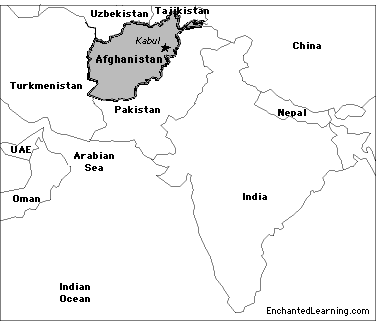
Capital: Kabul is the capital of Afghanistan.
Size: Afghanistan covers about 652,230 square kilometers (slightly smaller than the state of Texas). Afghanistan is the 41st largest country in the world.
Population: The people of Afghanistan are called Afghans. Afghanistan has the 41st largest population of any country in the world. The population of Afghanistan is about 29,121,286 (as of July, 2010).
Government: Afghanistan is a republic that is divided into 34 provinces. The National Holiday is Independence Day, which is celebrated on August 19 (Afghanistan became independent from the UK on August 19, 1919).
Language: The official languages are Afghan Persian (also called Dari or Farsi) and Pashto.
Education: Girls in Afghanistan go to school for an average of 5 years; boys go for an average of 11 years.
Literacy Rate: About 28% (less than a third) of the adults in Afghanistan can read and write. About 43% of the men and 12.6% of the women are literate.
Official Religion: Islam (99% of the people of Afghanistan are Muslim; 80% Sunni Muslim and 19% Shia Muslim).
The black, red, and green flag was flown in Afghanistan from 1930 until 1973. It was again flown over the presidential palace in Kabul on February 5, 2002, in a ceremony led by interim Afghan leader Hamid Karzai. This flag replaced the flag of the overthrown Taliban.
Major Rivers: There are no major rivers in Afghanistan.
Mountain Ranges: The Hindu Kush Mountains are a mountain range that separate the north of Afghanistan from the south).
Highest Point: The highest point in Afghanistan is Noshak (or Noshaq), at 7,485 meters above sea level. It is located in northeastern Afghanistan in the Hindu Kush mountain range.
Lowest Point: The lowest point in Afghanistan is Amu Darya (258 m above sea level), located in the northeastern Vakhan (Wakhan Corridor).
Natural Resources: natural gas, petroleum, coal, copper, chromite, talc, barites, sulfur, lead, zinc, iron ore, salt, precious and semiprecious stones
Major Industries: small-scale production of textiles, soap, furniture, shoes, fertilizer, apparel, food-products, non-alcoholic beverages, mineral water, cement; handwoven carpets; natural gas, coal, copper.
Agricultural Products: opium, wheat, fruits, nuts; wool, mutton, sheepskins, lambskins.

Afghanistan's FlagEnchantedLearning.com
All About Afghanistan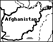
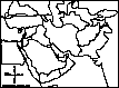
Map/Quiz Printout
Location: Afghanistan (officially called the Islamic Republic of Afghanistan) is a small, landlocked country in Southwestern Asia (in the Middle East). Afghanistan is bordered by Pakistan, Iran, Turkmenistan, Uzbekistan, Tajikistan, and China.
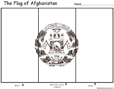
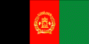
 Afghanistan's Flag: The flag of Afghanistan is composed of three equal vertical bars of black, red, and green, with the white coat of arms of Afghanistan in the center; this flag is known as the "King's flag." Each bar is twice as long as it is wide. The coat of arms depicts part of a mosque, sheaves of wheat, two banners, the date 1298 (1919 in the Gregorian calendar, the year Afghanistan gained independence from the UK), and an Arabic inscription that reads, "There is no God but Allah and Muhammed is his messenger."
Climate: Afghanistan's climate ranges from arid (dry) to semiarid. Winters are very cold and summers are very hot.
Related Activities and Printouts:
Afghanistan: Outline Map Printout Go to an outline map of Afghanistan to print. |
Afghanistan: Map Quiz Worksheets Go to printable map quiz activities that require research (using an atlas or other geography reference): a simple map research activity, a medium-level map research activity, or an advanced map research activity. |
 Flag of Afghanistan to Color Color a blackline master (printout) of the flag of Afghanistan. |
 Flag of Afghanistan A page on the flag plus a quiz to print. |
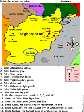 Afghanistan: Follow the Instructions Color Afghanistan according to simple directions, such as, "Color the Indus River light blue." Or go to the answers. |
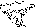 Asia: Outline Map Printout An outline map of Asia to print. |
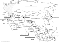 Asia: Label Me! Printout Label the map of Asia. Answers |
Middle East Geography Pages on the geography of the Mideast. |
 Middle East Map: Label Me! Printout Label a map of the Middle East. Answers |
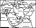
 Middle East: Outline Map Printout An outline map of the Middle East to print. |
Reference:
CIA World Factbook
Enchanted Learning®
Over 35,000 Web Pages
Sample Pages for Prospective Subscribers, or click below
|
Overview of Site What's New Enchanted Learning Home Monthly Activity Calendar Books to Print Site Index K-3 Crafts K-3 Themes Little Explorers Picture dictionary PreK/K Activities Rebus Rhymes Stories Writing Cloze Activities Essay Topics Newspaper Writing Activities Parts of Speech Fiction The Test of Time
|
Biology Animal Printouts Biology Label Printouts Biomes Birds Butterflies Dinosaurs Food Chain Human Anatomy Mammals Plants Rainforests Sharks Whales Physical Sciences: K-12 Astronomy The Earth Geology Hurricanes Landforms Oceans Tsunami Volcano |
Languages Dutch French German Italian Japanese (Romaji) Portuguese Spanish Swedish Geography/History Explorers Flags Geography Inventors US History Other Topics Art and Artists Calendars College Finder Crafts Graphic Organizers Label Me! Printouts Math Music Word Wheels |
Click to read our Privacy Policy
| Search the Enchanted Learning website for: |