
|
| You might also like: | Fact or Opinion? Geography, A Worksheet. | Where Do You Live? USA | Where I Live: the USA and Canada | The Seven Continents Book | World Flags Book | Today's featured page: Astronomy Crafts for Kids |
| Our subscribers' grade-level estimate for this page: 4th - 5th |
| EnchantedLearning.com K-3 Geography Activities at Enchanted Learning Crafts, Quizzes, Information, and Explorers |
Click Here for K-3 Themes |
| AFRICAN COUNTRIES: A COLORING BOOK TO PRINT 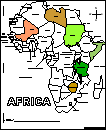 Print a coloring book of African countries. When you're done, locate the countries on a map of Africa, then label and color them. |
AFRICAN CRAFTS |
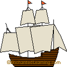
COLUMBUS' VOYAGE: MAP AND SHIPS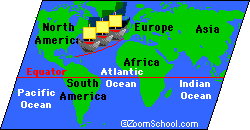 Make a map of Columbus' voyage and tiny replicas of his three ships. |
EARTH PENDANT
A simple Earth pendant or light-catcher. |
PAPIER-MÂCHÉ GLOBE
A globe made from a balloon, newspaper, and flour. |
Geography Bulletin Board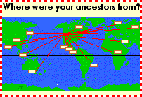 A geography-themed bulletin board that traces each student's ancestry. |
 Make your own flag A printout in which you can make a flag to represent a state, a school, a classroom, a club, a family, a person, etc. |
PILGRIMS' VOYAGE: MAP AND THE MAYFLOWER Make a map of the Pilgrims' voyage and a tiny replica of the Mayflower. |
Printable Geography Books:
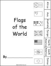 Flags A short printable book on world flags. There are pages on flags from each of the seven continents plus a few extra flags. |
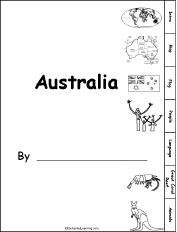 Australia: Tab Book A book about Australia for fluent readers with pages on the map, flag, language, people, the Great Barrier Reef, and unusual animals. |
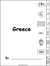 Greece: Tab Book A book about Greece for fluent readers with pages on the map, flag, language, Ancient Greece, the Olympics, and the Greek Gods and Mount Olympus. |
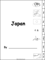 Japan: Tab Book A book about Japan for fluent readers with pages on the map, flag, language, origami, haiku, and Mt. Fuji. |
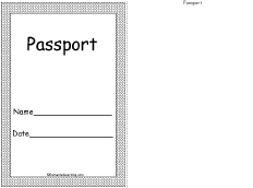 Passport Printable Book A printable student "Passport." The student can pretend to travel to many countries; for each country, the passport should be "stamped." Have the student make a stamp for each visited country. |
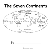 The Seven Continents A short activity book on the continents to print for early readers. There are pages on each of the seven continents. |
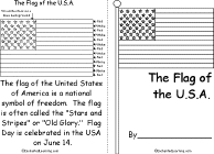 The US Flag A short, printable book on the history of the US flag. |
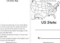 US State A short, printable book on a US state. To complete the book, the student must research a US state, draw its map, draw its flag, and answer simple questions about the state. |
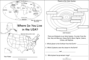 Where Do You Live in the USA A short activity book on geography to print for fluent readers; the student reads maps, draws maps, and answers questions abouts maps and direction. There are pages on the Solar System, the continents, North America, USA and the student's state. |
 Where I Live (Asia) A short activity book on geography to print for early readers. There are pages on the Solar System, the continents, Asia, and the student's home. |
 Where I Live (Australia) A short activity book on geography to print for early readers. There are pages on the Solar System, the continents, Australia (states and territories), and the student's address. |
 Where I Live (Europe) A short activity book on geography to print for early readers. There are pages on the Solar System, the continents, Europe, and the student's home. |
 Where I Live (UK) A short activity book on geography to print for early readers. There are pages on the Solar System, the continents, Europe, the UK, and the student's home. |
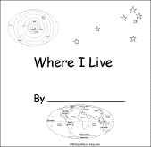
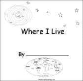 Where I Live (USA and Canada) A short activity book on geography to print for early readers. There are pages on the Solar System, the continents, North America, Canada or the USA and the student's address. |
Simple Geography Information:
 Zoom School Africa Learn about Africa's geography, animals, explorers, etc., using a pictorial interface. |
 Zoom School Antarctica Learn about Antarctica's geography, animals, explorers, etc., using a pictorial interface. |
 Zoom School Australia Learn about Antarctica's geography, animals, explorers, etc., using a pictorial interface. |
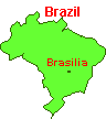 Zoom School Brazil Learn about Brazil's flag, animals, map, rainforests, etc., using a pictorial interface. |
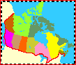 Zoom School Canada Learn about Canada's flag, animals, map, etc., using a pictorial interface. |
 Zoom School China Learn about China's flag, animals, map, the Great Wall, etc., using a pictorial interface. |
 Zoom School Japan Learn about Japan's flag, animals, map, language, etc., using a pictorial interface. |
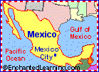 Zoom School Mexico Learn about Mexico's flag, animals, map, language, explorers, etc., using a pictorial interface. |
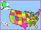 Zoom School USA Learn about the United States of America's flag, animals, map, presidents, etc., using a pictorial interface. |
The Oceans Learn why oceans are salty and blue, and what causes waves and tides. Also, you can do ocean crafts or print out pages on ocean animals. |
Simple Geography Quizzes/Info:
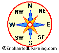
 Compass Directions in English A Label Me! Printout Label the compass directions in English. Answers |
Compass Directions in French A Label Me! Printout Label the compass directions in French. Answers |
Compass Directions in German A Label Me! Printout Label the compass directions in German. Answers |
Compass Directions in Italian A Label Me! Printout Label the compass directions in Italian. Answers |
Compass Directions in Spanish A Label Me! Printout Label the compass directions in Spanish. Answers |
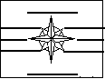
 Compass Rose A compass rose is a design on a map that shows directions. Fill in the directions on this compass rose printout. |
 The Continents Label the continents, the poles, and the equator. Answers |
 Oceans of the World Label the Arctic, Atlantic, Indian, Pacific, and Southern Oceans. Answers |
 USA Map: Where I Live Write your country, state, and city, and then find and label your state (and a few other geographical features). |
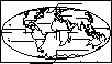 World Map Label the continents, oceans, poles, equator, and prime meridian. Answers |
World Map: Where I Live Answer questions about where you live and label the world map. Answers |
 Mayflower Map/Quiz Printout Read the map, then answer the geography questions about the Pilgrims' crossing on the Mayflower. |
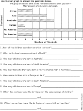 Reading a Bar Graph Worksheet #9: Continent of Birth The student uses a bar graph of their continent of birth to answer questions on this simple worksheet. Or go to the answers. |
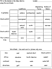 Idea Matrix Puzzle: Geography Words In this sorting and classifying activity, the student fills in the blanks (and some categories) in an idea matrix using a word bank. Classify and sort the words by category and word structure. Word bank: Asia, Africa, continent, directions, east, elevation, Europe, gulf, nautical chart, North America, scale, sea, Stars with N, summit, waterfall, west. Or go to the answers. Or go to a pdf of the puzzle and the answers. |
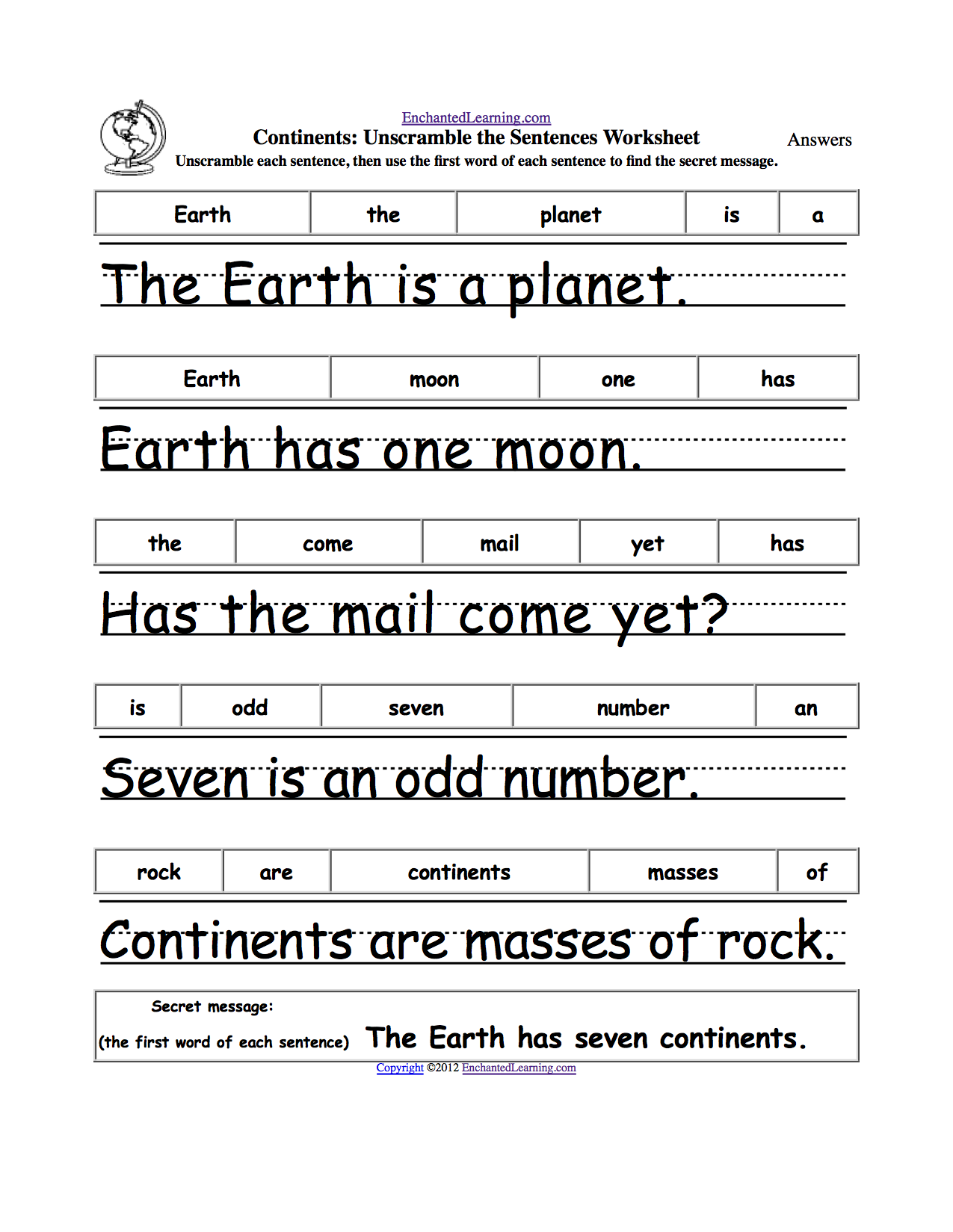 Continents: Unscramble the Sentences Worksheet Unscramble the words of each simple sentence, then use the first word of each sentence to form the secret message, "The Earth has seven continents." Or go to the answer page. |
 Oceans: Unscramble the Sentences Worksheet Unscramble the words of each simple sentence, then use the first word of each sentence to form the secret message, "The Earth has five oceans." Or go to the answer page. |
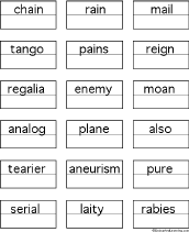
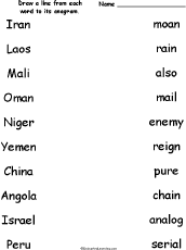 Match the Country Name Anagrams Draw a line from each country name to its anagram. Words: Iran/rain, Laos/also, Mali/mail, Oman/moan, Niger/reign, Yemen/enemy, China/chain, Angola/analog, Israel/serial, Peru/pure. Or go to the answers. |
 Country Name Anagram Puzzle Worksheet On this printable worksheet, the student writes a country name for each anagram. Or go to the answers. |
Nepal panel penal plane Country Anagrams A web page with the names of many countries that are anagrams. Some examples include: China/chain, Mail/mail, Niger/reign, Peru/pure, Spain/pains, Tonga/tango. |
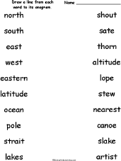 Match the Geography Anagrams Draw a line from each geography-related word to its anagram. Words: north/thorn, south/shout, east/sate, west/stew, eastern/nearest, latitude/altitude, ocean/canoe, pole/lope, strait/artist, lakes/slake. Or go to the answers. |
 Geography Anagram Puzzle Worksheet On this printable worksheet, the student writes a geography anagram for each word. Or go to the answers. |
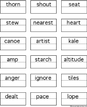
eastern earnest nearest plane Geography Anagrams A web page with geography terms that are anagrams. Some examples include: latitude/altitude, nation/anoint, region/ignore. |
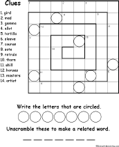
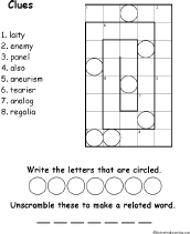 Spiral Country Anagram Picture Puzzle Worksheet #1 Solve the country anagram clues then put the words in the spiral puzzle. An anagram is a word that is made by rearranging the letters of another word. This is a tricky puzzle. Or go to the answers. |
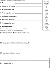 Landform Words Grammar Potpourri Worksheet Find synonyms, antonyms, homonyms, anagram, and compound word, then capitalize, punctuate, and correct the spelling of sentences. Or go to the answers. |
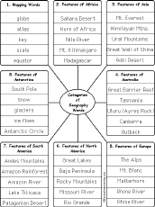 Write Geography Words by Category Write geography words by category (write 5 words per category). The categories include: Mapping Words, Features of Africa, Features of Asia, Features of Australia, Features of Europe, Features of North America, Features of South America, Features of Antarctica. Or go to sample answers. |
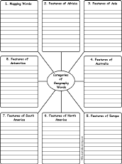 Write Geography Words by Category Write 10 geography words for each category. The categories include: Mapping Words, Features of Africa, Features of Asia, Features of Australia, Features of Europe, Features of North America, Features of South America, Features of Antarctica. Or go to sample answers. |
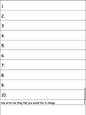 Write Ten Things About Your City A one-page printable worksheet. Write ten things about your city (plus one thing you would like to change). |
Write Ten Things About Your Neighborhood A one-page printable worksheet. Write ten things about your neighborhood (plus one thing you would like to change). |
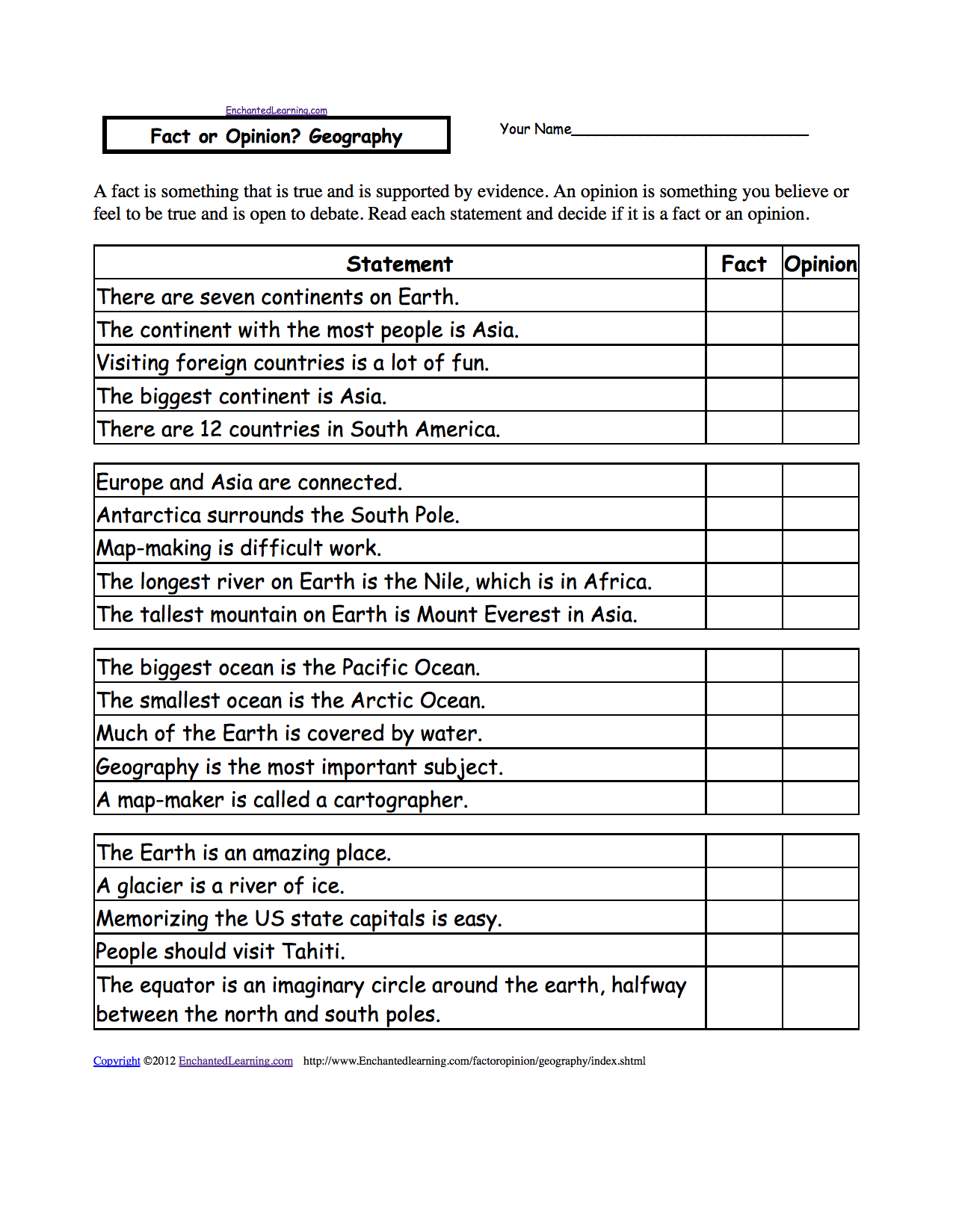 Fact or Opinion? Geography Determine if the statements are facts or opinions. A fact is supported by evidence and can be proven; an opinion is how you feel about something and is open to debate. Or go to the answers. Or go to a pdf of the worksheet and answers (subscribers only). |
Work Bank Printouts:
 List of Country Names This is a word bank of country names. |
List of Landforms This is a word bank of landforms. |
List of Geography Words This is a word bank of geography words. |
Country Name Anagrams This is a word bank of anagrams of country names. An anagram is a word or phrase that is made by rearranging the letters of another word or phrase. For example, China is an anagram of chain. |
Geography Word Anagrams This is a word bank of anagrams of geography words. An anagram is a word or phrase that is made by rearranging the letters of another word or phrase. For example, latitude is an anagram of altitude. |
Landforms and Geography Anagrams:
An anagram is a word or phrase that is made by rearranging the letters of another word or phrase. For example, note is an anagram of tone.
|
arch char |
arc car |
arete eater |
atoll allot |
cape pace |
capes paces space |
cavern craven |
charts starch |
chasm machs |
contour crouton |
|
crater carter tracer |
dale deal lade lead |
dam mad |
delta dealt |
deltas lasted salted slated |
desert deters rested |
deserts dessert |
dome demo mode |
drainage gardenia |
dune nude |
|
earth hater heart |
east eats sate seat teas |
eastern earnest nearest |
everglade leveraged |
field filed |
fissure fussier |
forest fortes foster softer |
gaps gasp |
grid gird |
hills shill |
|
inlets enlist listen silent tinsel |
isle leis lies |
islet tiles stile |
lake kale leak |
lakes leaks kales slake |
latitude altitude |
levees sleeve |
littoral tortilla |
magma gamma |
mantle lament mantel mental |
|
map amp |
marsh harms |
marshes mashers smasher |
mesa same seam |
meander renamed |
miles limes slime smile |
mire emir rime |
moor room |
moraine romaine |
nation anoint |
|
north thorn |
ocean canoe |
parks spark |
peaks speak |
pikes spike |
plains spinal |
plate petal pleat leapt |
pole lope |
point pinto piton |
range anger |
|
ravine naiver vainer |
reef free |
region ignore |
ria air |
ridge dirge |
rift frit |
rise ires sire |
rock cork |
scale laces |
scrub curbs |
|
seashore seahorse |
shoal halos |
shore heros hoers horse |
slope lopes poles |
slough ghouls |
soil oils |
source course |
south shout |
strait artist traits |
stream master tamers |
|
terrace caterer retrace |
terrain retrain trainer |
thickets thickest thickset |
vale veal |
vales salve slave veals |
vista vitas |
west stew wets |
woodland download |
Landform and Geography Anagram Activities:
Geography Anagram Puzzle Worksheet On this printable worksheet, the student writes a geography anagram for each word. Or go to the answers. |
Match the Geography Anagrams Draw a line from each geography-related word to its anagram. Words: north/thorn, south/shout, east/sate, west/stew, eastern/nearest, latitude/altitude, ocean/canoe, pole/lope, strait/artist, lakes/slake. Or go to the answers. |
 Spiral Landforms Anagram Picture Puzzle Worksheet #1 Solve the landforms anagram clues then put the words in the spiral puzzle. An anagram is a word that is made by rearranging the letters of another word. This is a tricky puzzle. Or go to the answers. |
 Spiral Landforms Anagram Picture Puzzle Worksheet #2 Solve the landforms anagram clues then put the words in the spiral puzzle. An anagram is a word that is made by rearranging the letters of another word. This is a tricky puzzle. Or go to the answers. |
 Spiral Landforms Anagram Picture Puzzle Worksheet #3 Solve the landforms anagram clues then put the words in the spiral puzzle. An anagram is a word that is made by rearranging the letters of another word. This is a tricky puzzle. Or go to the answers. |
Country Name Anagrams:
An anagram is a word or phrase that is made by rearranging the letters of another word or phrase. For example, note is an anagram of tone.
|
Algeria regalia |
Angola analog |
Burma rumba umbra |
China chain |
Eritrea tearier |
Italy laity |
Iran rain |
|
Israel serial |
Laos also |
Mali |
Micronesia acrimonies |
Nepal panel penal plane |
Niger reign |
Oman moan |
|
Peru pure |
Serbia rabies |
Spain pains |
Suriname aneurism |
Tonga tango |
Wales weals |
Yemen enemy |
Country Name Anagram Activities:
Country Name Anagram Puzzle Worksheet On this printable worksheet, the student writes a country name for each anagram. Or go to the answers. |
Match the Country Name Anagrams Draw a line from each country name to its anagram. Words: Iran/rain, Laos/also, Mali/mail, Oman/moan, Niger/reign, Yemen/enemy, China/chain, Angola/analog, Israel/serial, Peru/pure. Or go to the answers. |
Spiral Country Name Anagram Picture Puzzle Worksheet #1 Solve the country anagram clues then put the words in the spiral puzzle. An anagram is a word that is made by rearranging the letters of another word. This is a tricky puzzle. Or go to the answers. |
Geography Word Pieces Puzzles:
 Biome Word Pieces Puzzle In this puzzle, combine pairs of word segments to make biome-related spelling words. Words: cave, desert, grassland, chaparrel, marsh, prairie, rainforest, reef, savanna, swamp, taiga, tundra. Or go to the answers. |
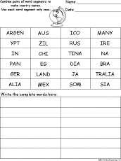 Country Name Word Pieces Puzzle In this puzzle, combine pairs of word segments to make country names. Words: Argentina, Australia, Brazil, China, Egypt, India, Japan, Germany, Ireland, Mexico, Russia, Somalia. Or go to the answers. |
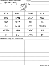 Country Name Word Pieces Puzzle #2 In this puzzle, combine pairs of word segments to make country names. Words: Canada, Cuba, Ethiopia, Greece, Indonesia, Italy, Nigeria, Pakistan, Peru, Spain, Sudan, Thailand. Or go to the answers. |
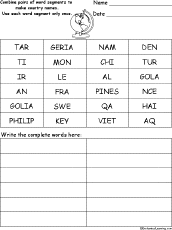 Country Name Word Pieces Puzzle #3 In this puzzle, combine pairs of word segments to make country names. Words: Algeria, Angola, Chile, France, Haiti, Iraq, Mongolia, Philippines, Qatar, Sweden, Turkey, Vietnam. Or go to the answers. |
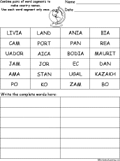 Country Name Word Pieces Puzzle #4 In this puzzle, combine pairs of word segments to make country names. Words: Bolivia, Cambodia, Ecuador, Jamaica, Jordan, Kazakhstan, Korea, Mauritania, Panama, Poland, Portugal, Zambia. Or go to the answers. |
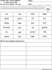
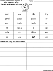 Geography Word Pieces Puzzle In this puzzle, combine pairs of word segments to make geography-related spelling words. Words: compass, country, east, latitude, legend, longitude, meridian, map, north, scale, south, west. Or go to the answers. |
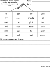 Landform Word Pieces Puzzle In this puzzle, combine pairs of word segments to make landform-related spelling words. Words: canyon, cliff, continent, fjord, glacier, island, isthmus, mountain, peninsula, valley. Or go to the answers. |
Follow the Instructions - Maps:
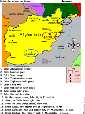 Afghanistan: Follow the Instructions Color Afghanistan according to simple directions, such as, "Color the Indus River light blue." Or go to the answers. |
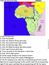 Africa: Follow the Instructions Color Africa according to simple directions, such as, "Trace the path of the Nile River in dark blue." Or go to the answers. |
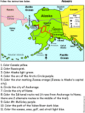 Alaska: Follow the Instructions Color Alaska according to simple directions, such as, "Color Alaska light green." Or go to the answers. |
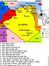 Algeria: Follow the Instructions Color Algeria according to simple directions, such as, "Circle Algiers, the capital city of Algeria, in red." Or go to the answers. |
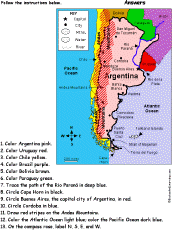 Argentina: Follow the Instructions Color Argentina according to simple directions, such as, "Trace the path of the Rio Paraná in deep blue." Or go to the answers. |
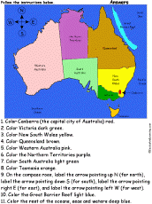 Australia: Follow the Instructions Color Australia according to simple directions, such as, "Color Victoria dark green." Or go to the answers. |
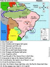 Brazil: Follow the Instructions Color Brazil according to simple directions, such as, "Draw green stripes on the Amazon Rainforest." Or go to the answers. |
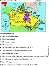 Canada: Follow the Instructions Color the Canada according to simple directions, such as, "Color Hudson Bay purple." Or go to the answers. |
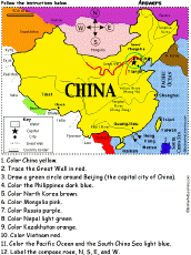 China: Follow the Instructions Color China according to simple directions, such as, "Trace the Great Wall in red." Or go to the answers. |
 Color and Count the Continents: Follow the Instructions Color and count the continents according to simple directions, such as, "How many continent start with the letter "A"?." Or go to the answers. |
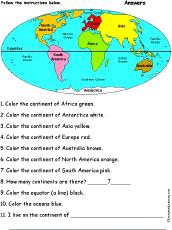 Continents: Follow the Instructions Color the continents according to simple directions, such as, "Color the continent of Africa green." Or go to the answers. |
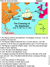 Crossing of the Mayflower: Follow the Instructions Color the map of the voyage of the Mayflower from England to America according to simple directions, such as, "Draw a dark blue circle around Plymouth Rock, Massachusetts." Or go to the answers. |
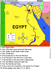 Egypt: Follow the Instructions Color Egypt according to simple directions, such as, "Trace the path of the Nile River in blue." Or go to the answers. |
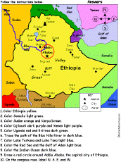 Ethiopia: Follow the Instructions Color Ethiopia according to simple directions, such as, "Trace the path of the Blue Nile River in dark blue." Or go to the answers. |
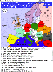 Europe #1: Follow the Instructions Color Europe according to simple directions, such as, "Trace the Arctic Circle in red." Or go to the answers. |
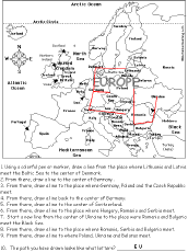
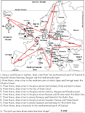 Europe #2: Follow the Instructions Draw a path in Europe according to simple directions, such as, "Draw a line back to the southernmost point of Iceland." Or go to the answers. Or go to a pdf of the worksheet and the answers. |
 Europe #3: Follow the Instructions Draw a path in Europe according to simple directions, such as, "Start a new line from the center of Ukraine to the place were Romania and Bulgaria meet the Black Sea." Or go to the answers. Or go to a pdf of the worksheet and the answers. |
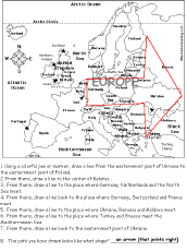 Europe #4: Follow the Instructions Draw a path in Europe according to simple directions, such as, "Start a new line from the center of Ukraine to the place were Romania and Bulgaria meet the Black Sea." Or go to the answers. Or go to a pdf of the worksheet and the answers. |
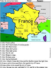 France: Follow the Instructions Color France according to simple directions, such as, "Color Mt. Blanc Brown." Or go to the answers. |
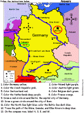 Germany: Follow the Instructions Color Germany according to simple directions, such as, "Draw a red circle around Berlin, the capital city of Germany." Or go to the answers. |
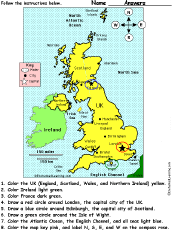 Great Britain and Northern Ireland: Follow the Instructions Color the United Kingdom of Great Britain and Northern Ireland according to simple directions, such as, "Draw a red circle around Edinburgh, the capital city of Scotland." Or go to the answers. |
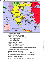 Greece: Follow the Instructions Color Greece according to simple directions, such as, "Draw a red circle around Athens, the capital city of Greece." Or go to the answers. |
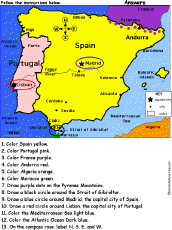 Iberian Peninsula: Spain and Portugal: Follow the Instructions Color Spain and Portugal according to simple directions, such as, "Draw a red circle around Lisbon, the capital city of Portugal." Or go to the answers. |
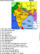 India: Follow the Instructions Color India according to simple directions, such as, "Trace the path of the Ganges River in blue." Or go to the answers. |
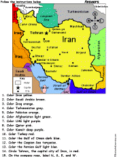 Iran: Follow the Instructions Color Iran according to simple directions, such as, "Color Iran yellow." Or go to the answers. |
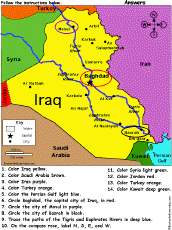 Iraq: Follow the Instructions Color Iraq according to simple directions, such as, "Trace the paths of the Tigris and Euphrates Rivers in deep blue." Or go to the answers. |
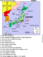 Japan: Follow the Instructions Color Japan according to simple directions, such as, "Color Mt. Fuji purple." Or go to the answers. |
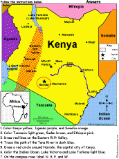 Kenya: Follow the Instructions Draw and color Kenya according to simple directions, such as, "Draw a red circle around Nairobi, the capital city of Kenya." Or go to the answers. |
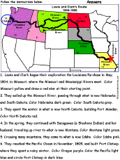 Lewis and Clark: Follow the Instructions Color the trail that Lewis and Clark and the Corps of Discovery followed in their exploration of the Louisiana Purchase according to simple directions, such as, "Draw a red star at their starting point." For beginning readers. Or go to the answers. |
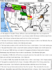 Lewis and Clark: Follow the Instructions #2 Color the trail that Lewis and Clark and the Corps of Discovery followed in their exploration of the Louisiana Purchase according to simple directions, such as, "Draw a red star at their starting point." For fluent readers. Or go to the answers. |
 Map Reading Activity Printout #1 Color the map, read compass directions, estimate distance, and read latitude and longitude. Answers |
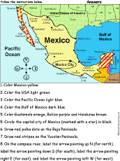 Mexico: Follow the Instructions Color Mexico according to simple directions, such as, "Color Mexico yellow." Or go to the answers. |
 Middle East: Follow the Instructions Color the mideast according to simple directions, such as, "Circle both Bahrain and Cyprus in red." Or go to the answers. |
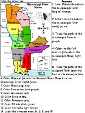 Mississippi River States: Follow the Instructions Color a map of the Mississippi River states in the USA according to the directions, such as, "Color Minnesota (where the Mississippi River begins) orange." States: Minnesota, Wisconsin, Iowa, Illinois, Missouri, Kentucky, Tennessee, Arkansas, Mississippi, Louisiana. Or go to the answers. |
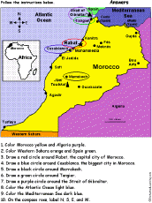 Morocco: Follow the Instructions Draw and color Morocco according to simple directions, such as, "Draw a blue circle around Casablanca, the biggest city in Morocco." Or go to the answers. |
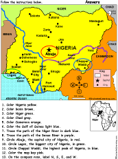 Nigeria: Follow the Instructions Color Nigeria according to simple directions, such as, "Color Pakistan yellow." Or go to the answers. |
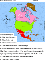 North America: Follow the Instructions Color North America according to simple directions, such as, "Color the USA green." Or go to the answers. |
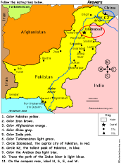 Pakistan: Follow the Instructions Color Pakistan according to simple directions, such as, "Color Pakistan yellow." Or go to the answers. |
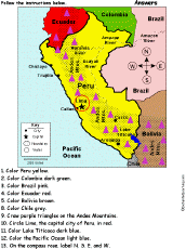 Peru: Follow the Instructions Color Peru according to simple directions, such as, "Color Lake Titicaca dark blue." Or go to the answers. |
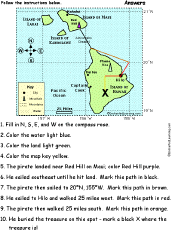 Pirate Map: Follow the Instructions Color a pirate map according to simple directions, such as, "The pirate then walked 25 miles south. Mark this path in orange." Or go to the answers. |
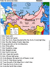 Russia: Follow the Instructions Color Russia according to simple directions, such as, "Trace the Arctic Circle in red." Or go to the answers. |
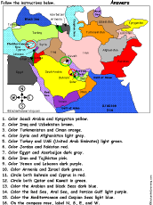
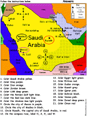 Saudi Arabia: Follow the Instructions Draw and color Saudi Arabia according to simple directions, such as, "Color the Persian Gulf light blue." Or go to the answers. |
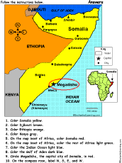 Somalia: Follow the Instructions Draw and color Somalia according to simple directions, such as, "Draw a red circle around Mogadishu, the capital city of Somalia." Or go to the answers. |
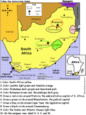 South Africa: Follow the Instructions Draw and color South Africa according to simple directions, such as, "Draw a red circle around Pretoria, the administrative capital city of South Africa." Or go to the answers. |
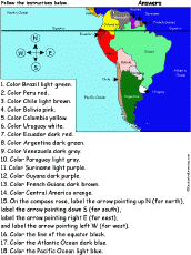 South America: Follow the Instructions Draw and color South America according to simple directions, such as, "Color Peru red." Or go to the answers. |
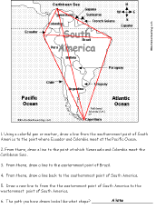 South America: Follow the Instructions #2 Draw lines on the map of South America according to simple directions, such as, "Draw a line back to the easternmost point of Brazil." Or go to the answers. |
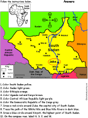 South Sudan: Follow the Instructions Draw and color South Sudan according to simple directions, such as, "Draw a red circle around Juba, the capital city of Sudan." Or go to the answers. |
Spain and Portugal: Follow the Instructions Color Spain and Portugal according to simple directions, such as, "Draw a red circle around Lisbon, the capital city of Portugal." Or go to the answers. |
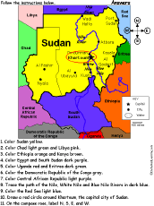 Sudan: Follow the Instructions Draw and color Sudan according to simple directions, such as, "Draw a red circle around Khartoum, the capital city of Sudan." Or go to the answers. |
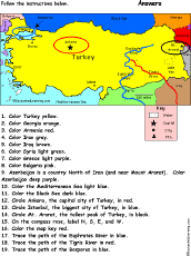 Turkey: Follow the Instructions Color Turkey according to simple directions, such as, "Trace the path of the Bosporus in blue." Or go to the answers. |
United Kingdom of Great Britain and Northern Ireland: Follow the Instructions Color the United Kingdom of Great Britain and Northern Ireland according to simple directions, such as, "Draw a red circle around Edinburgh, the capital city of Scotland." Or go to the answers. |
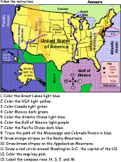 United States of America: Follow the Instructions Color the USA according to simple directions, such as, "Draw orange stripes on the Rocky Mountains." Or go to the answers. |
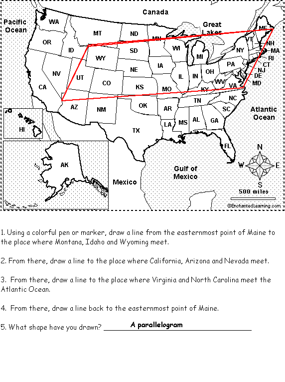 United States of America: Follow the Instructions #2 Draw lines on the USA map according to simple directions, such as, "Draw a line back to the easternmost point of Maine." Or go to the answers. Or go to a pdf of the worksheet and the answers. |
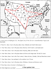 United States of America: Follow the Instructions #3 Draw lines on the USA map according to simple directions, such as, "From D.C., draw a line to the place where Iowa, Nebraska and South Dakota meet." Or go to the answers. Or go to a pdf of the worksheet and the answers. |
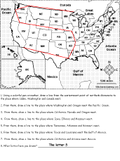 United States of America: Follow the Instructions #4 Draw lines on the USA map according to simple directions, such as, "From there, draw a line to the place where Washington and Oregon meet the Pacific Ocean." Or go to the answers. Or go to a pdf of the worksheet and the answers. |
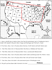 United States of America: Follow the Instructions #5 Draw lines on the USA map according to simple directions, such as, "Draw a line to the place where New York and Vermont meet Canada." Or go to the answers. Or go to a pdf of the worksheet and the answers. |
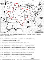 United States of America: Follow the Instructions #6 Draw lines on the USA map according to simple directions, such as, "... draw a line to the center of Utah." Or go to the answers. Or go to a pdf of the worksheet and the answers. |
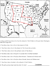 United States of America: Follow the Instructions #7 Draw lines on the USA map according to simple directions, such as, "Draw a line back to the center of North Dakota." Or go to the answers. Or go to a pdf of the worksheet and the answers. |
US States
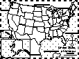
USA Map: Find Your State Find and label your state in the USA, and label other important features. Answers |
USA Map: Where I Live Write your country, state, and city, and then find and label your state (and a few other geographical features). |
 Color and Count the US States #1: Follow the Instructions Color and count the continental US States according to simple directions, such as, "How many continental US states border the Pacific Ocean? Name them." Or go to the answers. |
 Color and Count the US States #2: Follow the Instructions Color and count the continental US States according to simple directions, such as, "How many continental US states border Mexico? Name them." Or go to the answers. |
 Color and Count the US States #3: Follow the Instructions Color and count the continental US States according to simple directions, such as, "How many continental US states start with the word "New"? Name them." Or go to the answers. |
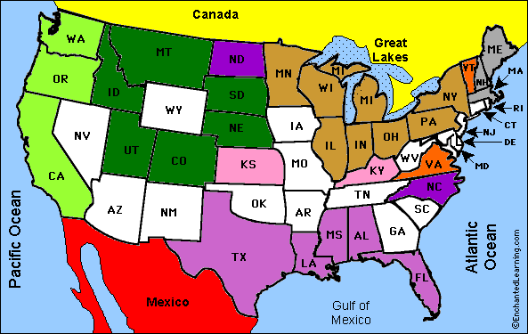
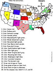
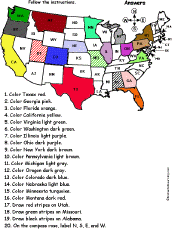 US States Map #1A: Follow the Instructions Color states on a map of the contiguous US according to the directions, such as, "Color Texas red." The states are labeled with their abbreviations. States: Texas, Georgia, Florida, California, Virginia, Washington, Illinois, Ohio, New York, Pennsylvania, Michigan, Oregon, Colorado, Nebraska, Montana, Utah, Missouri, Alabama. Or go to the answers. |
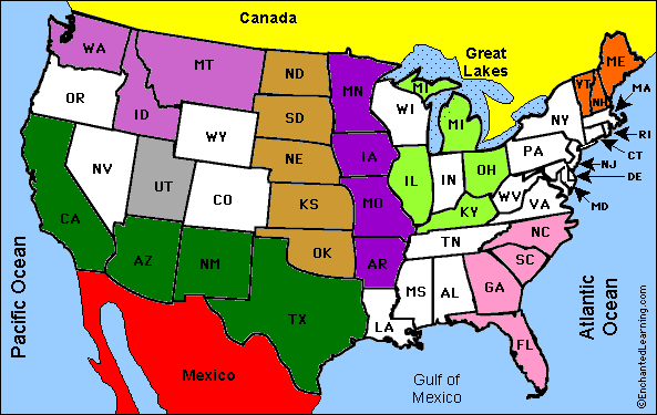
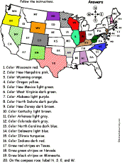
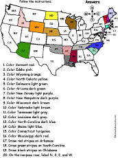 US States Map #2A: Follow the Instructions Color states on a map of the contiguous US according to the directions, such as, "Color Arizona dark green." The states are labeled with their abbreviations. States: Vermont, Idaho, Wyoming, North Dakota, Delaware, Arizona, New Jersey, New Hampshire, Wisconsin, Nebraska, Tennessee, Louisiana, North Carolina, Maine, Connecticut, Mississippi, Arkansas, South Carolina, Oklahoma. Or go to the answers. |
 US States Map #3A: Follow the Instructions Color states on a map of the contiguous US according to the directions, such as, "Draw green stripes on New York." The states are labeled with their abbreviations. States: Kansas, Indiana, Kentucky, Nevada, Massachusetts, Rhode Island, Maryland, New Mexico, Iowa, South Dakota, Ohio, West Virginia, Wyoming, Washington, Louisiana, Florida, Texas, New York, Montana. Or go to the answers. |
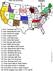 US States Map #4A: Follow the Instructions Color states on a map of the contiguous US according to the directions, such as, "Draw green stripes on New York." The states are labeled with their abbreviations. States: Tennessee, Massachusetts, California, Oregon, Utah, Maine, Georgia, Idaho, New Mexico, Pennsylvania, Michigan, Oklahoma, Kansas, Kentucky, New York, Wisconsin, South Dakota, Alabama, West Virginia. Or go to the answers. |
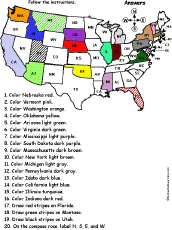 US States Map #5A: Follow the Instructions Color states on a map of the contiguous US according to the directions, such as, "Color Washington orange." The states are labeled with their abbreviations. States: Washington, Arizona, Virginia, Mississippi, South Dakota, Massachusetts, New York, Michigan, Pennsylvania, Idaho, California, Illinois, Indiana, Florida, Montana, Utah. Or go to the answers. |
 US States Map #6A: Follow the Instructions Color states on a map of the contiguous US according to the directions, such as, "Color Wisonsin red." The states are labeled with their abbreviations. States: Wisconsin, New Hampshire, Wyoming, Oregon, New Mexico, West Virginia, Alabama, North Dakota, New Jersey, Kentucky, Arkansas, Colorado, North Carolina, Delaware, Illinois, Indiana, Texas, Nevada, Minnesota. Or go to the answers. |
 US States Map #1: Follow the Instructions Fill in 10 state names given clues and then color part of a US map according to the directions, such as, "______ is the smallest state in the USA. Color it blue." States: Alaska, Arizona, California, Florida, Illinois, Indiana, Louisiana, New York, Oregon, Rhode Island. Or go to the answers. |
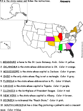 US States Map #2: Follow the Instructions Fill in 10 state names given clues and then color part of a US map according to the directions, such as, "______ is nicknamed the "Peach State." Color it pink." States: Florida, Georgia, Kansas, Illinois, Mississippi, Missouri, New York, Ohio, Oklahoma, South Carolina. Or go to the answers. |
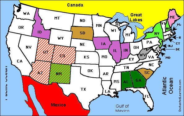
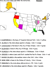
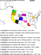 US States Map #3: Follow the Instructions Fill in 10 state names given clues and then color part of a US map according to the directions, such as, "______ is the home of Mt. Rushmore. Color it purple." States: Arizona, California, Colorado, Louisiana, Ohio, Oklahoma, Oregon, South Dakota, Washington, Wyoming. Or go to the answers. |
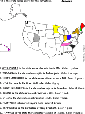 US States Map #4: Follow the Instructions Fill in 10 state names given clues and then color part of a US map according to the directions, such as, "______ is the home to the Great Salt Lake. Color it gray." States: Hawaii, Indiana, Maine, Minnesota, New Hampshire, New York, Ohio, South Carolina, Tennessee, Utah. Or go to the answers. |
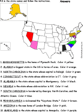 US States Map #5: Follow the Instructions Fill in 10 state names given clues and then color part of a US map according to the directions, such as, "______ is the home of Plymouth Rock. Color it yellow." States: Alabama, Alaska, Arizona, Connecticut, Maryland, Massachusetts, Nevada, North Carolina, Pennsylvania, South Carolina, Pennsylvania. Or go to the answers. |
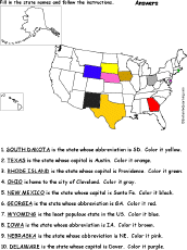 US States Map #6: Follow the Instructions Fill in 10 state names given clues and then color part of a US map according to the directions, such as, "______ is the state whose capital is Austin. Color it orange." States: Delaware, Georgia, Iowa, Nebraska, New Mexico. Ohio, Rhode Island, South Dakota, Texas, Wyoming. Or go to the answers. |
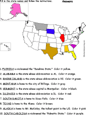 US States Map #7: Follow the Instructions Fill in 10 state names given clues and then color part of a US map according to the directions, such as, "______ is nicknamed the "Sunshine State." Color it yellow." States: Alabama, Alaska, Florida, Illinois, Montana, Rhode Island, South Carolina, South Dakota, Texas, Vermont. Or go to the answers. |
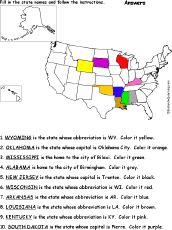 US States Map #8: Follow the Instructions Fill in 10 state names given clues and then color part of a US map according to the directions, such as, "______ is the state whose abbreviation is WY. Color it yellow." States: Alabama, Arkansas, Kentucky, Louisiana, Mississippi, New Jersey, South Dakota, Wisconsin, Wyoming. Or go to the answers. |
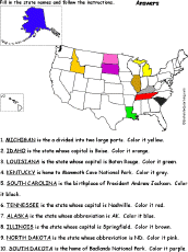 US States Map #9: Follow the Instructions Fill in 10 state names given clues and then color part of a US map according to the directions, such as, "______ is a state divided into two large parts. Color it yellow." States: Alaska, Idaho, Kentucky, Louisiana, Michigan, North Dakota, South Carolina, South Dakota, Tennessee. Or go to the answers. |
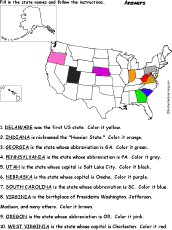 US States Map #10: Follow the Instructions Fill in 10 state names given clues and then color part of a US map according to the directions, such as, "______ was the first US state. Color it yellow." States: Delaware, Georgia, Nebraska, Oregon, Pennsylvania, South Carolina, Utah, West Virginia, Virginia. Or go to the answers. |
| EnchantedLearning.com World Geography |
 Flags |
| Africa | Antarctica | Asia | Australia/Oceania | Central America/ Caribbean | Europe | Mideast | North America | South America | USA |
| A | B | C | D | E | F | G | H | I | J | K | L | M | N | O | P | Q | R | S | T | U | V | W | X | Y | Z |
| All Themes | Animals | Food | People | Plants | Sports | Time and Calendar | Holidays |
|---|
| A | B | C | D | E | F | G | H | I | J | K | L | M | N | O | P | Q | R | S | T | U | V | W | X | Y | Z |
Enchanted Learning®
Over 35,000 Web Pages
Sample Pages for Prospective Subscribers, or click below
|
Overview of Site What's New Enchanted Learning Home Monthly Activity Calendar Books to Print Site Index K-3 Crafts K-3 Themes Little Explorers Picture dictionary PreK/K Activities Rebus Rhymes Stories Writing Cloze Activities Essay Topics Newspaper Writing Activities Parts of Speech Fiction The Test of Time
|
Biology Animal Printouts Biology Label Printouts Biomes Birds Butterflies Dinosaurs Food Chain Human Anatomy Mammals Plants Rainforests Sharks Whales Physical Sciences: K-12 Astronomy The Earth Geology Hurricanes Landforms Oceans Tsunami Volcano |
Languages Dutch French German Italian Japanese (Romaji) Portuguese Spanish Swedish Geography/History Explorers Flags Geography Inventors US History Other Topics Art and Artists Calendars College Finder Crafts Graphic Organizers Label Me! Printouts Math Music Word Wheels |
Click to read our Privacy Policy
| Search the Enchanted Learning website for: |